| |
|---|---|
| |
|
| ABSTRACT |
|---|
|
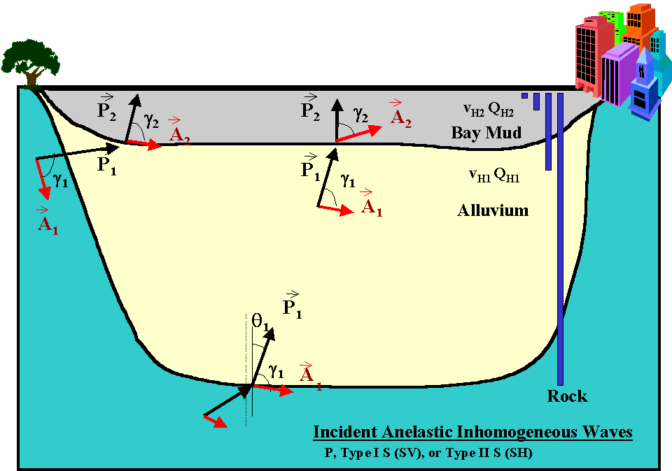
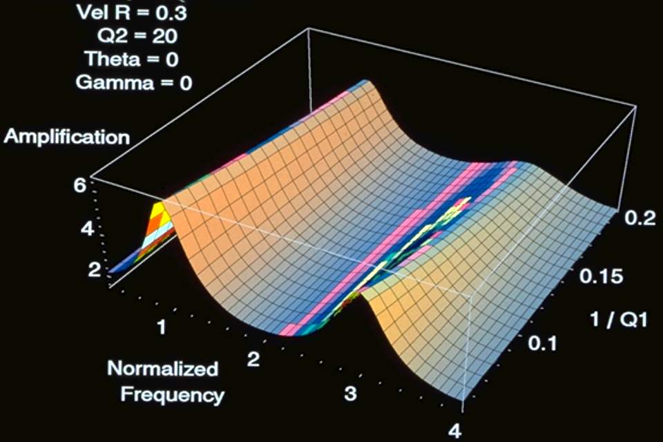
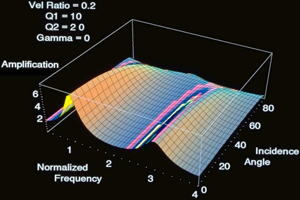
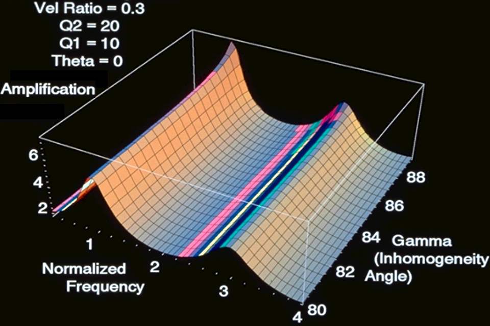
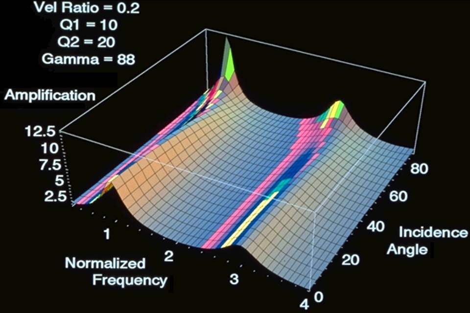
Four borehole arrays have been in operation since 1992 in the city of San Francisco, California, to provide integrated data sets on the response of soft-soil deposits to earthquake ground motions. The borehole arrays extend through thick layers of soft water-saturated soils of Holocene age and older more consolidated soils of Pleistocene age into bedrock at depths up to 100 m. The arrays are located in areas of San Francisco that experienced major damage due to ground-motion amplification and liquefaction during both the great California earthquake of 1906 and the Loma Prieta earthquake of 1989. The arrays provide wide-dynamic range measurement of three-component acceleration at each depth and collocated simultaneous pressure and velocity at some depths. Complementary surface and structural response arrays are installed at a number of nearby locations. The arrays are designed to provide an integrated set of data pertinent to addressing a wide variety of scientific and engineering issues. An issue of special interest is the nonlinear or anelastic response of soft soil deposits at high strain levels. Theoretical result show that anelasticity plays a major role in determining the response of soil layers. Exact models have been developed to account for contrasts in anelastic properties at boundaries and resultant inhomogeneity of propagating wave fields. Exact anelastic models predict that significant amounts of energy may be trapped in soil basins with resultant larger amplifications than can be predicted using conventional homogeneous wave-field models with damping. |
| 1. INTRODUCTION |
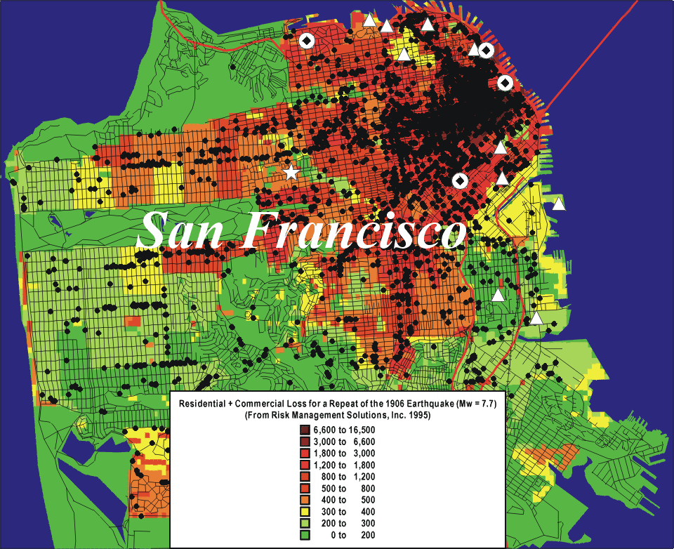
|---|
|
Structural damage and consequent loss of life from earthquakes is often concentrated in areas underlain by soft soils. Damage from modern earthquakes such as those affecting Mexico City (1985), Leninakan, Armenia (1988), San Francisco, California (Loma Prieta 1989), and Kobe, Japan (1995) imply that a major portion of the damage occurred in areas underlain by soft soils. These increased amounts of damage are due to amplification effects of soft soil deposits on certain frequencies of ground shaking and in some cases associated soil failures. Nevertheless, relatively scarce empirical information exists concerning the in-situ response of such deposits. Few strong-motion recordings have been obtained in boreholes necessary to define the actual amplification characteristics as a function of input ground shaking. In the city of San Francisco, damage from both the great California earthquake of 1906 and the Loma Prieta earthquake of 1989 was concentrated in areas underlain by soft soil deposits. Many of these areas are along the margins of San Francisco Bay and are densely urbanized. However, no in-situ borehole measurements of the response of these deposits have yet been obtained at damaging levels of motion. Such measurements of the next large damaging earthquake will be of special importance for mitigation of future earthquake losses. Several important questions exist concerning the in-situ response of soft soil deposits at damaging levels of shaking. A question of particular interest concerns the role of non-linearity in modifying the in-situ amplification characteristics of soft soil deposits as a function of shaking amplitude. This is a major issue yet to be resolved with in-situ evidence. Other questions concerning changes in constitutive properties with duration, ground motion characteristics necessary for the onset of liquefaction, and the influence of basin geometry also are of considerable interest.. This paper describes a set of integrated arrays installed in the city of San Francisco to address these questions. It describes the design objectives of the arrays, their location, geologic setting, seismic and geologic information, and instrumentation configuration. |
| |
|---|---|
|
| 2. GENERAL DESIGN OBJECTIVES |
|---|
|
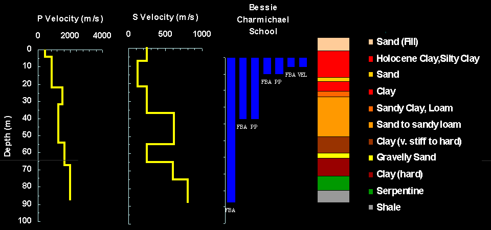
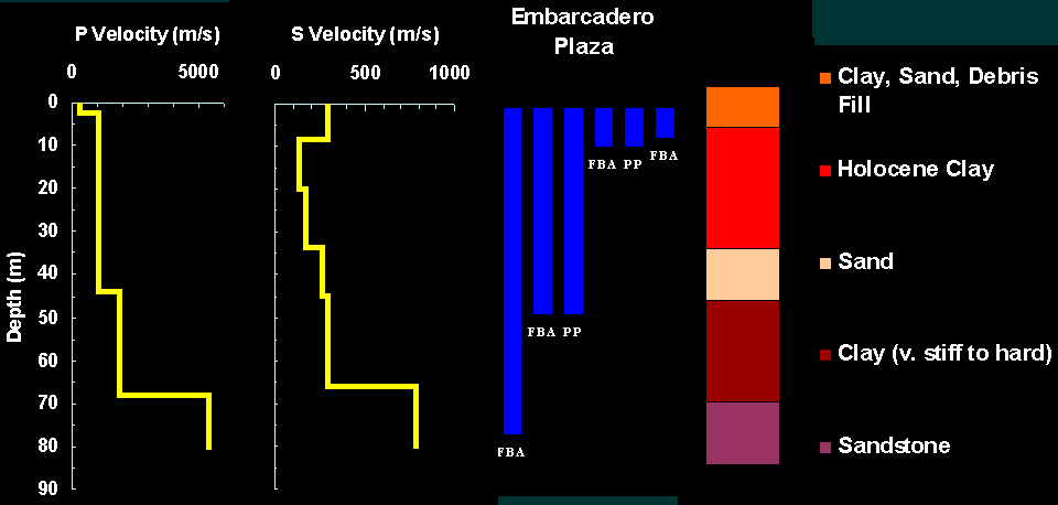
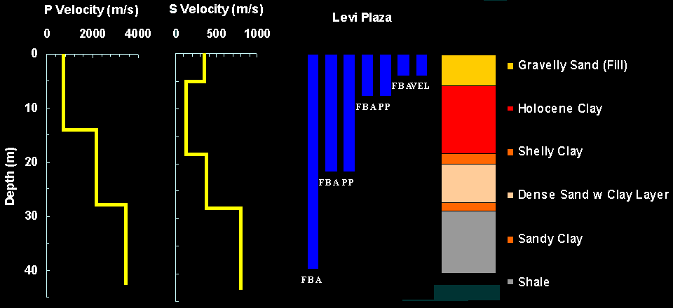
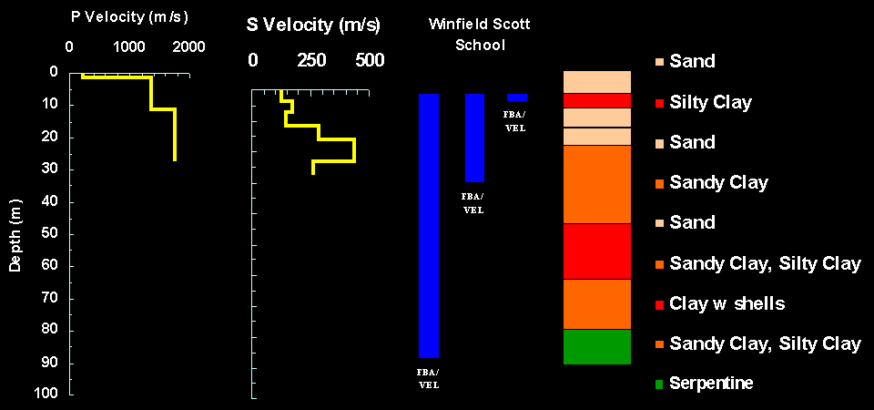
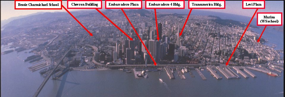
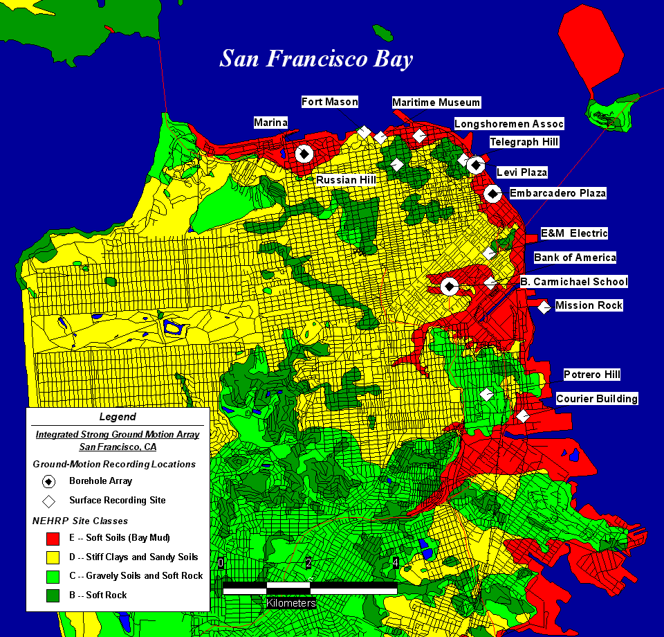
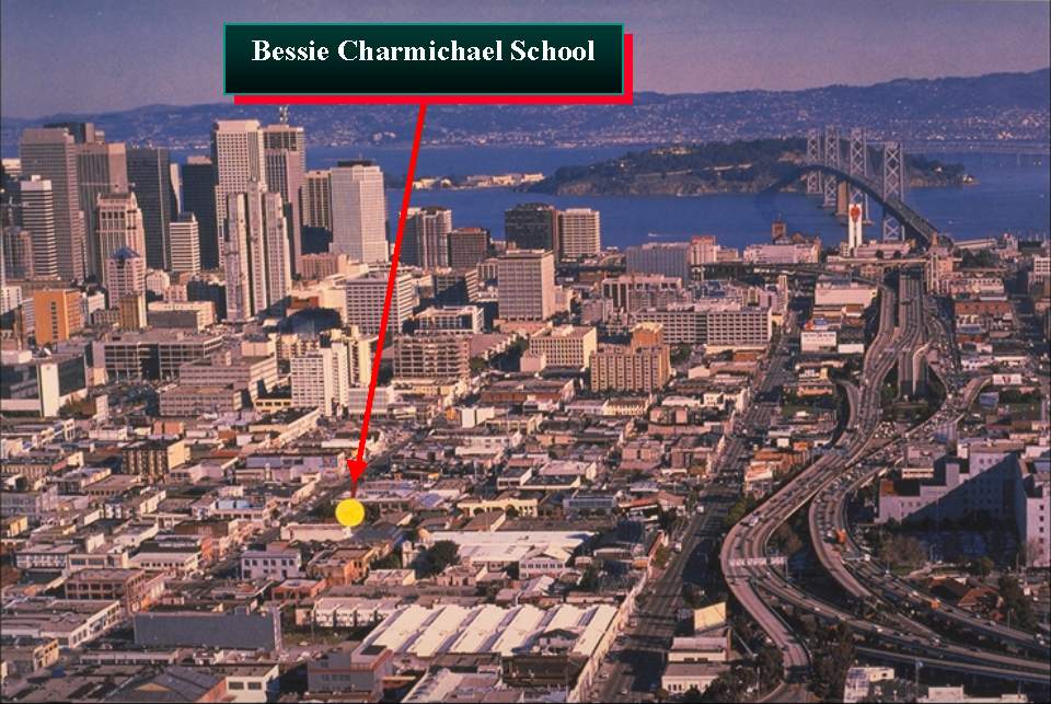
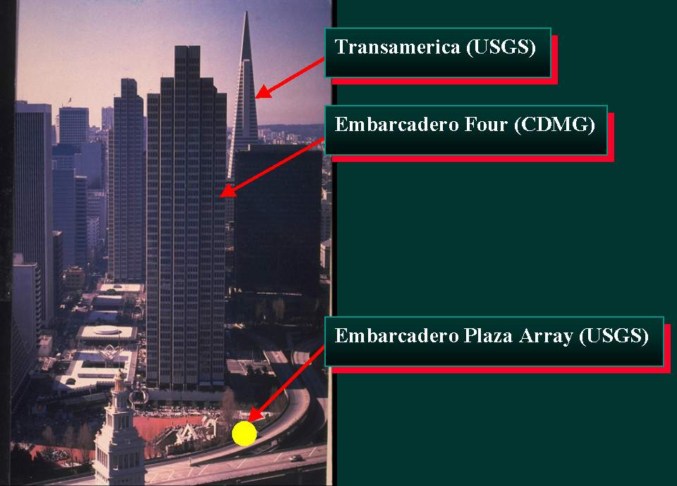
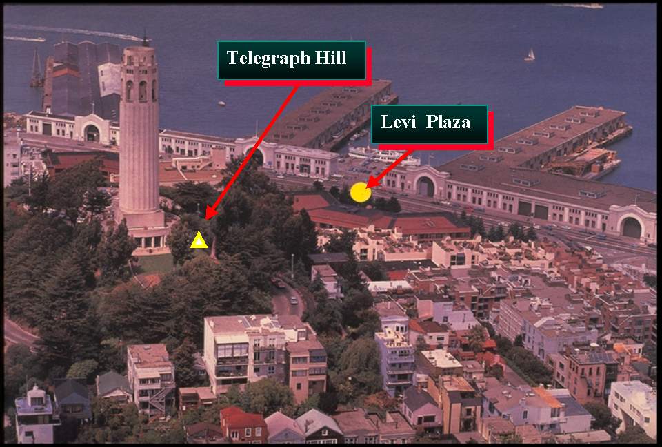
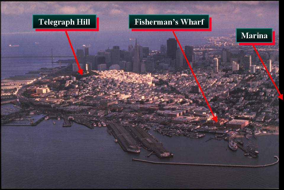
The integrated strong-motion soil response arrays in San Francisco operated by the U.S. Geological Survey are designed to provide comprehensive data on the response of "soft soils" at four different locations in the city underlain by soft water saturated clays, sands, and silts. Evidence for liquefaction during the earthquakes exists at three of the four sites. Major concentrations of damage occurred in these areas during both the 1906 and 1989 earthquakes. Locations of the arrays are shown in Figure 1. The arrays are located in the vicinity of Embarcadero Plaza (EMB) near lower market street, in Levi Strauss Plaza near the base of Telegraph Hill (LP), at Winfield Scott School in the Marina district (WSS), and at Bessie Carmichael School (BCS) in an area south of Market street. Surface installations of pairs of three component velocity and force-balance accelerometers are installed at four additional sites (see Figure 1). Measurements in these areas are particularly relevant for purposes of hazard mitigation, because a number of important facilities including high-rise buildings, apartment buildings, rapid transit facilities, bridges, freeway structures, harbor facilities and underground utilities are located in these areas. The arrays are designed to provide new in-situ data on the constitutive behavior of soils as a function of strain amplitude and liquefaction-induced failure. They are designed to complement strong-motion data recorded on nearby well-instrumented buildings together with data recorded at surface installations. The arrays are designed to provide an integrated set of data pertinent to addressing a wide variety of scientific and engineering issues. Each array includes sensors located at depths ranging from the surface to below the bedrock interface. Sensors at three of the borehole locations (BCS, LP, EMB) are at four different levels. Sensors at the WSS location are at three different depths. The complementary surface installations at four additional rock locations permit comparative studies of input motions as resolved both at the surface and at the bedrock interface beneath thick sections of soft soils. The borehole instrumentation at three of the locations includes two pairs of pore-pressure and force-balanced accelerometers (FBA) to provide in-situ collocated inferences of the temporal and spatial variations in pressure and ground displacements. Such collocated measurements using FBAs and dilatometers at other locations in California have been shown (Borcherdt, et al. 1988 and 1989) to provide important new information on in-situ material behavior as a function of time not provided by either measurement alone. These studies have shown that the simultaneous collocated measurements provide in-situ constitutive properties of the surrounding medium as a function of strain amplitude and number of cycles. The extent to which these concepts can be used to help resolve important issues regarding non-linear dynamic soil behavior and its role in influencing ground and structural response is an important design objective of the arrays at three of the locations (BCS, LP, EMB). Each of these arrays also includes two additional FBAs at greater depths including one in bedrock. Installation of an additional velocity transducer is being planned for each site. One of the arrays is designed with collocated sets of FBAs and velocity transducers (WSS). This array is intended to provide high resolution recordings ranging in amplitude from seismic background noise levels to damaging levels of shaking up to 2 g. The array, initially installed with velocity transducers, has provided an extensive data set interpreted by Liu, et al. (1992). |
| |
|---|---|
| |
| |
| |
|
| 3. GEOLOGIC SETTING |
|---|
|
The San Francisco Bay basin is a northwest-trending graben bounded on the northeast and southwest by the active Hayward and San Andreas faults. San Francisco Bay, located in the center of this graben, is bounded by marshlands, alluvial plains, and hills at distances of 1-15 km of the Coast Ranges. A wide variety of geologic units exist in close proximity throughout the region. They range from Mesozoic sedimentary and plutonic rocks in the hills, to Holocene alluvium and estuarine mud near the margins of the bay. Mesozoic and Tertiary rock units form the floor of the graben containing a sedimentary sequence of which the lower part was initially designated Older bay sediments and the upper part Younger bay mud. Geologic characteristics, physical properties, and seismic shear-wave velocities for the various surficial units in the San Francisco Bay region are summarized in detail by Borcherdt and Glassmoyer (1994). The Holocene Bay-mud unit is of particular interest, because it yields the largest amplifications of ground motion (Borcherdt 1970, Borcherdt and Gibbs 1976). Thick sections of Holocene Bay Mud exist at each of the borehole sites. In general, it is composed of unconsolidated, water-saturated, dark plastic clay and silty clay rich in organic material with local lenses of well-sorted silt and sand and some beds of peat. It attains thickness of 37 meters beneath the bay and thins to vanishing thickness along the margins of the bay. It generally contains more than 50 percent water. It is overlain at each of the borehole array locations by fill, comprised of hydraulically emplaced sands and clays or earth and rock with varying degrees of compaction. The Holocene bay-mud unit is mostly underlain by various Pleistocene deposits ranging in composition from weakly to moderately consolidated, deeply weathered, poorly sorted, irregularly interbedded clay, silt, sand, and gravel to loose, well-sorted, fine- to medium-grained sand with subordinate silt (Helley and Lajoie 1979). This Older Bay Sediment unit reaches overall thickness generally less than 200 m in the northern bay region. The semi-consolidated and consolidated units in the hills of the San Francisco Bay region include plutonic, volcanic, and a wide range of sedimentary rocks. Shear-wave velocities for these units range from about 425 m/s for soft sandstone to about 1,650 m/s for hard greenstone and fresh granite. The depths for sensors were chosen to monitor behavior of potentially liquefiable granular layers near the surface, the underlying Holocene Bay Mud, the underlying Older Bay Sediment layer and the underlying bedrock. |
| 4. GEOLOGIC AND SEISMIC LOGS |
|---|
|
During the initial drilling a relatively complete set of geologic and seismic logs were obtained at each of the sites (Gibbs 1994, Kayan, et al. 1990). A summary of the logs for each of the sites is shown in Figures 2, 3, 4, and 5. In addition, undisturbed samples were obtained and tested at the WSS site by Kayan et al. (1990). The logs at each of the sites shows evidence of a thin compacted layer of fill at the surface overlying deposits of soft clay, silty clay, and silts with the lowest shear wave velocities in the top 20 meters being slightly greater than 100 m/s. In general, the shear velocities increase with depth to values near 350 to 400 m/s then show a significant increase to values from 780 to slightly more than 800 m/s for the underlying bedrock. |
| 5. INSTRUMENTATION |
|---|
|
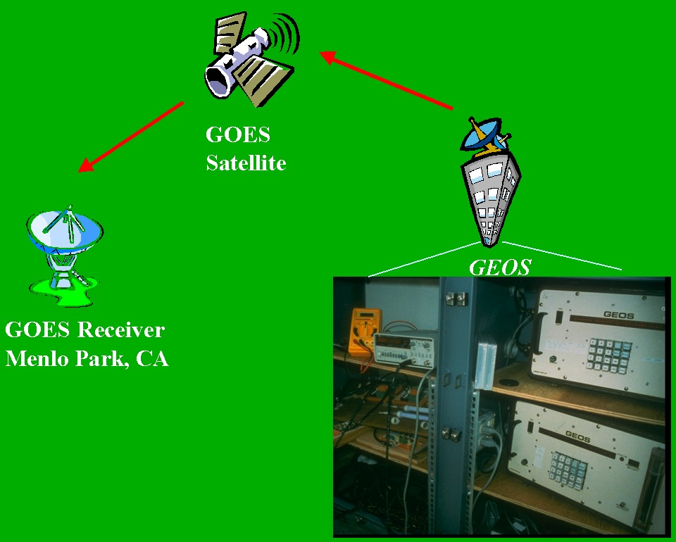
The sensors deployed for direct measurement of acceleration are three component borehole force-balance accelerometers with full scale at � 1 or � 2 g (� 5 volts), and frequency response from DC to 100 Hz, models FBA 13 and FBA 23 DH produced by Kinemetrics, Inc. The velocity transducers with a natural frequency of 2 Hz have been developed for borehole deployment (Liu, et al. 1991). The pore-pressure transducers are wide dynamic range (~140 dB) transducers with digital output proportional to pressure applied to a quartz crystal resonator, model 8DP depth sensor produced by Parascientific, Inc. Signals from each of the sensors at each location are recorded on site using broadband digital recorders (General Earthquake Observation Systems, GEOS, Borcherdt, et al. 1985) with event derived parameters transmitted and recorded in near real time via GOES satellite (Mueller et al. 1993). Signals from the various sensors are recorded at various gain levels depending on the depth and type of sensor. Gains up to 84 dB selectable in 6 dB steps are available to permit signals over a dynamic range near 180 dB at frequencies near 1 Hz to be resolved from a variety of sensor types. In general, gains for similar sensors in a single borehole array vary between 6 and 18 dB. Events are recorded in event triggered mode at 200 samples per second per channel using linear 16-bit linear analog to digital conversion. Absolute time and each of the various recording parameters are recorded simultaneously. Event and instrument parameters are transmitted at a selectable time interval usually chosen at to be less than 10 minutes via GOES satellite. Parameters such as trigger time, peak amplitude, time of peak amplitude and duration together with a variety of instrument status parameters are transmitted. The satellite transmissions permit the retrieval of critical event and instrument data in near real time. These data are especially useful in maintaining the array and initial evaluations following a major event. Sensor and recording system calibrations are recorded before and after each storage media change. Since installation of the array no earthquakes in the area have generated signals of sufficient strength to be recorded on the FBAs above the relatively high seismic background noise levels. Signals recorded on the velocity transducer array at the WSS site have been analyzed in detail by Liu, et al. (1992). |
| ||
|---|---|---|
| ||
|
| |
|---|---|
| |
|
| 6. CONCLUSIONS |
|---|
|
The borehole arrays are designed to provide in-situ data not previously available on the non-linear response of "soft soils" as a function of strain amplitude with and without liquefaction-induced failure. Each borehole array includes four three-component forced-balance accelerometers (FBA), two co-located wide dynamic-range pore-pressure transducers, and at least one velocity transducer. The co-located in-situ measurements of acceleration and pore pressure are designed to provide estimates of the constitutive properties as a function of time and strain amplitude that cannot be inferred from either measurement alone. A separate borehole array of velocity transducers collocated with FBAs installed at one of the sites (WSS) permits wide dynamic range signals useful for studies of non-linearity to be acquired. Complementary surface bedrock and structural response installations at several nearby sites permit a wide variety of additional scientific and engineering issues to be addressed. Sensor signals are recorded using broadband, wide dynamic range, on-site digital recorders (GEOS). Parameter information for each instrument and each recorded event is transmitted in near-real time via GOES satellite. No strong earthquake ground motions have occurred at the sites since installation of the arrays. |
| |
|---|---|
| |
| |
| |
| |
| |
| |
| |
|
| |
|---|---|
| |
| |
| |
| |
| |
| |
| |
|
| 7. REFERENCES |
|---|
|
Borcherdt, R.D., Fletcher, J.B., Jensen, E.G., Maxwell, G.L., Van Schaack, J.R., Warrick, R.E., Cranswick, E., Johnston, M.J.S., & McClearn, R., 1985. A General Earthquake Observation System (GEOS), Bull. Seismol. Soc. Am., 75, 1783-1825. |
![]()
The U.S. Department of the Interior Home Page is at http://www.doi.gov
The USGS Home Page is at http://www.usgs.gov
The USGS Geologic Division Home Page is at http://geology.usgs.gov
The USGS National Strong Motion Program Home Page is at http://earthquake.usgs.gov/monitoring/nsmp
The General Earthquake Observation System (GEOS) Home Page is at /GEOS/geos.html
The URL of this page is /PRESENTATIONS/San_Francisco_Array/San_Francisco_Array_Presentation_s.html
e-mail: glassmoyer@usgs.gov
or address:
Gary Glassmoyer
345 Middlefield Road M/S 977
Menlo Park, California 94025